
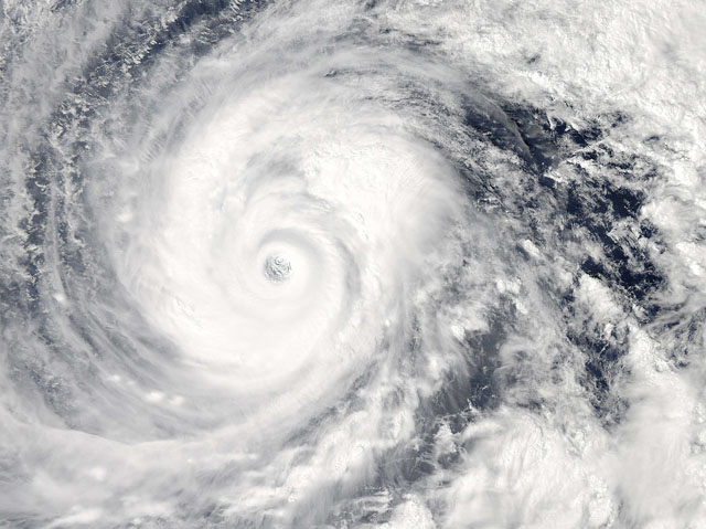
Typhoon Vongfong is seen in the Pacific Ocean as it approaches Japan’s main islands on its northward journey, in this Moderate-Resolution Imaging Spectroradiometer (MODIS) image taken from NASA’s Aqua satellite at 0425 GMT on October 9, 2014. Japan was bracing on Friday for its strongest storm this year, a super typhoon powering north toward the Okinawa island chain that threatens to rake a wide swathe of the nation with strong winds and torrential rain. Vongfong, which at one point rivaled last year’s devastating typhoon Haiyan in strength, was weakening slightly as it moved north across the open ocean, but still carried winds gusting as high as 259 kph (160 mph). Picture taken October 9, 2014. REUTERS/NASA/Handout via Reuters (PACIFIC OCEAN – Tags: ENVIRONMENT DISASTER TPX IMAGES OF THE DAY) ATTENTION EDITORS – THIS PICTURE WAS PROVIDED BY A THIRD PARTY. REUTERS IS UNABLE TO INDEPENDENTLY VERIFY THE AUTHENTICITY, CONTENT, LOCATION OR DATE OF THIS IMAGE. FOR EDITORIAL USE ONLY. NOT FOR SALE FOR MARKETING OR ADVERTISING CAMPAIGNS. THIS PICTURE WAS PROCESSED BY REUTERS TO ENHANCE QUALITY. AN UNPROCESSED VERSION WILL BE PROVIDED SEPARATELY