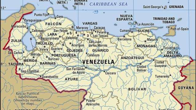
Venezuela, country located at the northern end of South America. It occupies a roughly triangular area that is larger than the combined areas of France and Germany. Venezuela is bounded by the Caribbean Sea and the Atlantic Ocean to the north, Guyana to the east, Brazil to the south, and Colombia to the southwest and west. The national capital, Caracas, is Venezuela’s primary centre of industry, commerce, education, and tourism.
By Britannica – Edwin Lieuwen
Jul 11, 2021
Venezuela administers a number of Caribbean islands and archipelagos, among which are Margarita Island, La Blanquilla, La Tortuga, Los Roques, and Los Monjes. Since the early 19th century Venezuela has claimed jurisdiction over Guyanese territory west of the Essequibo River totaling some 53,000 square miles (137,000 square km)—nearly two-thirds of the land area of Guyana. Venezuela also has had a long dispute with Colombia over the delimitation of maritime boundaries in the Gulf of Venezuela and around the archipelago of Los Monjes.
A physiographically diverse country, Venezuela incorporates the northern Andean mountain chains and interior highlands, the main portions of the Orinoco River basin with its expansive Llanos (plains), Lake Maracaibo, which is the largest lake in South America, and the spectacular Angel Falls, the world’s highest waterfall. The republic’s development pattern has been unique among Latin American countries in terms of the speed, sequence, and timing of economic and demographic growth. In the 20th century Venezuela was transformed from a relatively poor agrarian society to a rapidly urbanizing one, a condition made possible by exploiting huge petroleum reserves. These changes, however, were accompanied by imbalances among the country’s regions and socioeconomic groups, and Venezuela’s cities swelled because of a massive and largely uncontrolled migration from rural areas, as well as mass immigration, much of it illegal, from Colombia and other neighbours.
Venezuela, like many other Latin American countries, has a high percentage of urban poverty, a massive foreign debt, and widespread governmental patronage and corruption. Venezuela’s social and political ills have been compounded by natural disasters such as the floods that devastated sections of Caracas, La Guaira, and other coastal areas in late 1999. On the other hand, from 1958 to the early 21st century the republic was more democratic and politically stable than most other Latin American nations, and its economy benefited from a thriving petroleum industry that capitalized on the world’s largest known oil reserves. Venezuela’s position in the world became more precarious during the second decade of the 21st century as a result of the controversial rule of revolutionary leader Hugo Chávez, a significant decline in the fortunes of its petroleum industry, and the increasing authoritarianism of Chávez’s successor, Nicholás Maduro.
Land
The Venezuelan landscape includes towering mountains, tropical jungles, broad river plains, and arid coastal plains, all of which provide a diversity of natural habitats and a range of challenges to social integration and economic development.
Relief
Venezuela’s topography can be divided into three broad elevational divisions: the lowland plains, which rise from sea level to about 1,650 feet (500 metres), the mountains, which reach elevations of some 16,400 feet (5,000 metres), and the interior forested uplands, with scattered peaks above 6,550 feet (2,000 metres). Within these broad divisions, seven physiographic regions can be distinguished: the islands and coastal plains, including the Orinoco delta; the Lake Maracaibo Lowlands; the Mérida and Perijá ranges of the Andes Mountains; the coastal mountain system (with its Coastal and Interior ranges); the northwestern valleys and hill ranges, also called the Segovia Highlands; the Llanos; and the Guiana Highlands.
The islands and coastal plains are located in the north. They include the Caribbean “Islands to the Leeward,” such as Margarita and La Tortuga, and several peninsulas, including the head-shaped Paraguaná in the northwest and, in the northeast, Araya and Paria, the latter a finger of land pointing at Trinidad. The coastal plains extend from the Colombian border and the Gulf of Venezuela eastward to the foothills of the coastal mountains, which are broken in the east by the Unare River basin. Farther east is the Orinoco delta, which opens onto the Atlantic Ocean through a number of distributaries (caños); an early gateway to the settlement of the interior, it is a low, dank, and swampy area heavily dissected by streams.
…
Read More: Britannica – Venezuela
…

